- Printed on Polypropylene (plastic)
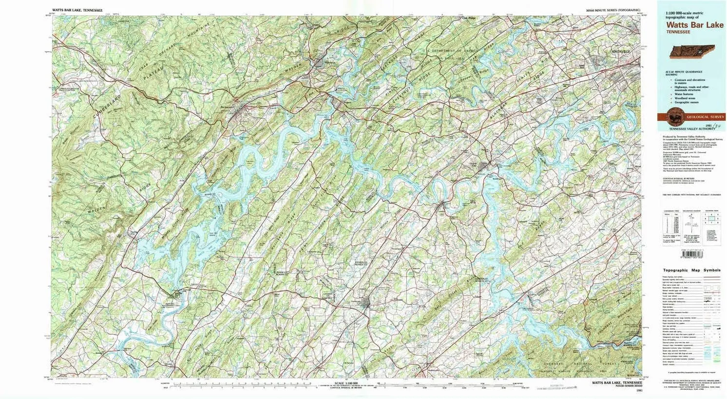
- USGS topographic map of Watts Bar Lake, TN, at 1:100000 scale. Heavier material. Waterproof. Tear-resistant. Foldable. Perfect for the outdoors.
- Cities, towns, villages: Chota (historical),Pennine,Dodson,Hideaway Hills,Fairlane,Decatur Hills,Cherry Branch,Trails West,Mars Hill,Allegheny Springs (historical),Mentor,Highland Hills,Ford,Bayside,Deerwood,Postoak,Mahoney Mill,Cannon Subdivision,Trigonia,Golden Meadows,Harriman Junction,Fagin,Slabtown,Bestview,Chestnut Hills,Orchard Valley Estates,Eagle Point Heights,Karns,Dyllis,Sunnyside,Moralfa,Midtown Heights,Station West,Post Oak Farms,Ladd Estates,Dixie Lee Junction,Bearden
- Islands: Bussell Island,Sand Island,Big Island (historical),Iron Hill Island,Bush Island,Duck Island
- Parks and forests: Rocky Hill Park,Loudon Marine Park,Fort Loudoun State Historic Area,Hornsby Hollow Recreation Area,Yarberry Peninsular Recreation Area,Manhattan Project National Historical Park,Rutain Park,Boy Scout Memorial,Lotterdale Cove Recreation Area,Mentor Community Park,Admiral Farragut Park,Melton Hill Park,Philadelphia Park,Carbide Park,Jones Bend Blount County Park,Rockwood Community Park,Ball Camp Park,Harrison Branch Recreation Area,Spring City Park
USGS topographic map of Watts Bar Lake, Tennessee, dated 1981, updated 1984.
Includes geographic coordinates (latitude and longitude), lines of elevation, bodies of water, roads, and more. This topo quad is suitable for recreational, outdoor uses, office applications, or wall map framing.
Printed on-demand by YellowMaps on the print material of your choice.
Shipping rolled from Minneapolis, MN, United States.
Product Number: USGS-5338896
Map Size: 24.1 inches high x 44.2 inches wide
Map Scale: 1:100000
Map Type: POD USGS Topographic Map
Map Series: HTMC
Map Version: Historical
Cell ID: 68556
Scan ID: 153428
Imprint Year: 1984
Woodland Tint: Yes
Visual Version Number: 2
Aerial Photo Year: 1981
Edit Year: 1981
Datum: NAD27
Map Projection: Universal Transverse Mercator
Map published by Tennessee Valley Authority
Map Language: English
Scanner Resolution: 600 dpi
Map Cell Name: Watts Bar Lake
Grid size: 30 X 60 Minute
Date on map: 1981
Geographical region: Tennessee, United States
Northern map edge Latitude: 36°
Southern map edge Latitude: 35.5°
Western map edge Longitude: -85°
Eastern map edge Longitude: -84°
Surrounding map sheets (copy & paste the Product No. in the search bar):
North: USGS-5334410,USGS-5339176,USGS-5334408,USGS-5338884,USGS-5339170
East: USGS-5339006,USGS-5339018,USGS-5339016,USGS-5339010,USGS-5333062
South: USGS-5332698,USGS-5332702,USGS-5338958,USGS-5338838,USGS-5338836
West: USGS-5336226,USGS-5338858,USGS-5338778,USGS-5339108,USGS-5339114
 #1 CVR C ARIEL OLIVETTI CARD STOCK VAR")


")


