- Printed on Tyvek® (synthetic)
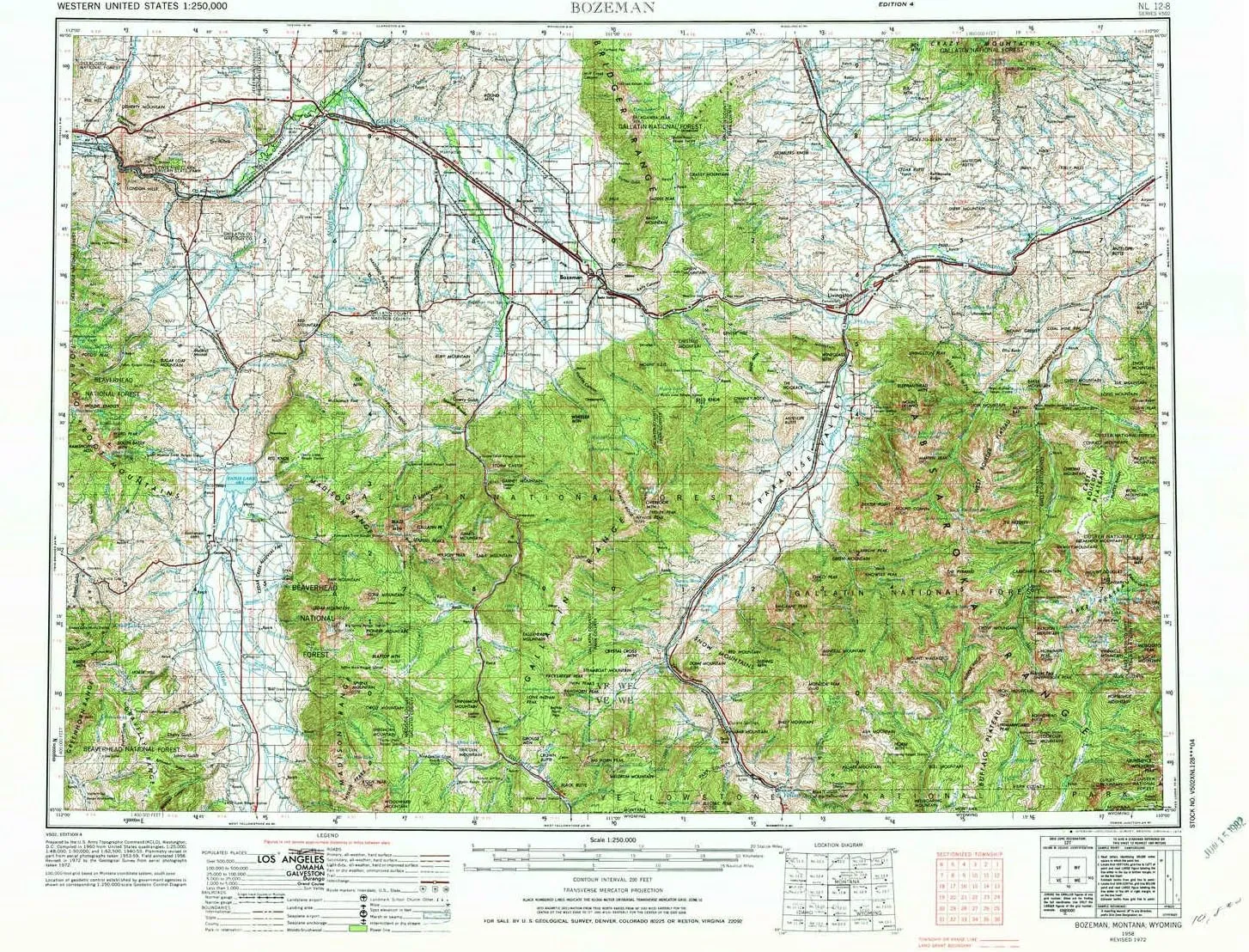
- USGS topographic map of Bozeman, MT, at 1:250000 scale. Lighter material. Waterproof. Tear-resistant. Foldable. Very durable. Perfect for backpacking and the outdoors.
- Cities, towns, villages: Buell,Minnesota Addition,Cardwell,Belgrade Junction,Pray,Summit,Chicory,Kotke,Lower Bridger (historical),Eau Clair (historical),Dailey (historical),High Ground Addition,Shaws,Sterling,Chico Hot Springs,Carney,Chadborn,Matthews,Corwin Springs,Sappington,Jardine,Willow Creek,Country Court,Chico,Accola,Belgrade,Shaw Place,Menard Wye,Electric,West Gallatin,Nelsons Crossing (historical),Monforton (historical),Chimney Rock,Storrs (historical),Grannis,Atkins
- Mountains: Madison Range,The Wedge,Spanish Peaks,Gallatin Range,Greenhorn Range,Burnt Top,Cameron Point,Kid Royal Mountain,Green Mountain,Naya Nuki Peak,Cinnamon Mountain,Mount Wallace,Noon Mark,Monitor Peak,Maltbys Mound,London Peak,Baldy Mountain,Sawtooth Mountain
- Valleys: Greer Gulch,Dry Hollow,Dry Canyon,Limestone Canyon,Fuller Draw,Grindstone Gulch,Cherry Gulch,Dry Gulch,Lewis Gulch,Oregon Valley,Miles Gulch,Wright Gulch,Mill Creek Canyon,Bachelor Gulch
USGS topographic map of Bozeman, Montana, dated 1958, updated 1974.
Includes geographic coordinates (latitude and longitude), lines of elevation, bodies of water, roads, and more. This topo quad is suitable for recreational, outdoor uses, office applications, or wall map framing.
Printed on-demand by YellowMaps on the print material of your choice.
Shipping rolled from Minneapolis, MN, United States.
Product Number: USGS-5401912
Map Size: 22.1 inches high x 29.1 inches wide
Map Scale: 1:250000
Map Type: POD USGS Topographic Map
Map Series: HTMC
Map Version: Historical
Cell ID: 75024
Scan ID: 268672
Imprint Year: 1974
Woodland Tint: Yes
Visual Version Number: 2
Aerial Photo Year: 1972
Edit Year: 1972
Field Check Year: 1958
Datum: Unstated
Map Projection: Transverse Mercator
Map published by United States Geological Survey
Map published by: Military, Other
Map Language: English
Scanner Resolution: 600 dpi
Map Cell Name: Bozeman
Grid size: 1 X 2 Degree
Date on map: 1958
Geographical region: Montana, United States
Northern map edge Latitude: 46°
Southern map edge Latitude: 45°
Western map edge Longitude: -112°
Eastern map edge Longitude: -110°
Surrounding map sheets (copy & paste the Product No. in the search bar):
North: USGS-5400860,USGS-5400866,USGS-5402070,USGS-5618576,USGS-5402074
East: USGS-5400824,USGS-5401898,USGS-5401900,USGS-5392618,USGS-5400826
South: USGS-5401554,USGS-5437594,USGS-5401132,USGS-5395200,USGS-5437600
West: USGS-5618548,USGS-5401952,USGS-5618552,USGS-5618546,USGS-5401946

")


