- Printed on Polypropylene (plastic)
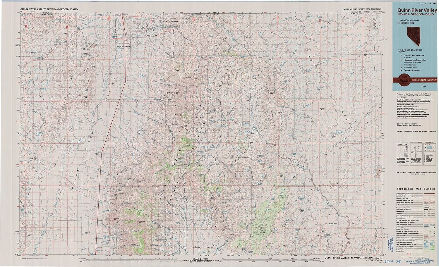
- USGS topographic map of Quinn River Valley, NV, at 1:100000 scale. Heavier material. Waterproof. Tear-resistant. Foldable. Perfect for the outdoors.
- Cities, towns, villages: Rebel Creek (historical),Platora,Spring City (historical),Gouge Eye,Orovada,National (historical),Queen City (historical),McDermitt,Cordero,Cañon Creek Station (historical)
- Islands: Consult topo map preview for visible islands.
- Parks and forests: Santa Rosa Ranger District,Santa Rosa State Game Refuge
USGS topographic map of Quinn River Valley, Nevada, dated 1985, updated 1985.
Includes geographic coordinates (latitude and longitude), lines of elevation, bodies of water, roads, and more. This topo quad is suitable for recreational, outdoor uses, office applications, or wall map framing.
Printed on-demand by YellowMaps on the print material of your choice.
Shipping rolled from Minneapolis, MN, United States.
Product Number: USGS-5573572
Map Size: 24.2 inches high x 39.7 inches wide
Map Scale: 1:100000
Map Type: POD USGS Topographic Map
Map Series: HTMC
Map Version: Historical
Cell ID: 68206
Scan ID: 519526
Imprint Year: 1985
Woodland Tint: Yes
Aerial Photo Year: 1980
Edit Year: 1985
Datum: NAD27
Map Projection: Universal Transverse Mercator
Map published by United States Geological Survey
Map Language: English
Scanner Resolution: 508 dpi
Map Cell Name: Quinn River Valley
Grid size: 30 X 60 Minute
Date on map: 1985
Geographical region: Nevada, United States
Northern map edge Latitude: 42°
Southern map edge Latitude: 41.5°
Western map edge Longitude: -118°
Eastern map edge Longitude: -117°
Surrounding map sheets (copy & paste the Product No. in the search bar):
North: USGS-5545872,USGS-5545868,USGS-5545874,USGS-5545750,USGS-5545866
East: USGS-5568834,USGS-5573444,USGS-5573442
South: USGS-5572130,USGS-5568338,USGS-5573556,USGS-5572132
West: USGS-5573470,USGS-5573250,USGS-5573252,USGS-5573466,USGS-5573464
![Guy Harvey Break Away Dual-Layer Case in Onyx Black Designed for iPhone 15 by cellhelmet [Compatible with MagSafe] 13ft Drop Proof Certified | Shock Proof - Durable | As Seen on Shark Tank](https://www.flintstart.shop/image/guy-harvey-break-away-dual-layer-case-in-onyx-black-designed-for-iphone-15-by-cellhelmet-compatible-with-magsafe-13ft-drop-proof-certified-shock-proof-durable-as-seen-on-shark-tank_Z7ABX9_300x.webp "Guy Harvey Break Away Dual-Layer Case in Onyx Black Designed for iPhone 15 by cellhelmet [Compatible with MagSafe] 13ft Drop Proof Certified | Shock Proof - Durable | As Seen on Shark Tank")


