- Printed on Tyvek® (synthetic)
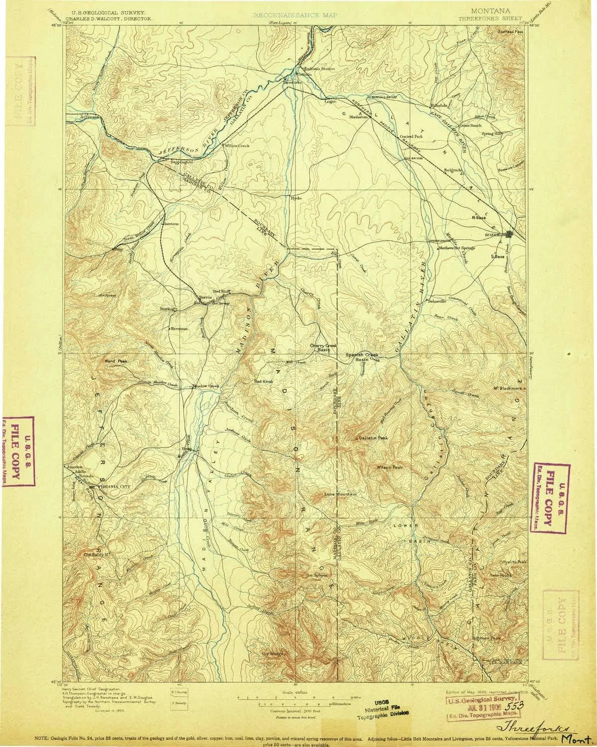
- USGS topographic map of Three Forks, MT, at 1:250000 scale. Lighter material. Waterproof. Tear-resistant. Foldable. Very durable. Perfect for backpacking and the outdoors.
- Cities, towns, villages: Copper City,Beacon Point,Pony,King Arthur Park,Cowboys Heaven,Edilou,Stringtown (historical),Summit Valley,Adobe (historical),Central City (historical),Kerns,Sheds (historical),Reese Creek (historical),Cardwell,Menard Wye,Churchill,Gallatin Gateway,Springhill,Ennis,Patterson,Springhill Park,Three Forks,Menard,Lower Madison (historical),Sappington,Varney,Belgrade,Manhattan,Big Sky Mountain Village,Wisner Crossing,Beals,Red Bluff,Story,Gallatin (historical),Shaws
- Mountains: Gallatin Range,Gravelly Range,The Wedge,Tobacco Root Mountains,Eaglehead Mountain,Round Mountain,Cinnamon Mountain,Sheep Mountain,London Hills,Ramshorn Mountain,Horse Hill,Avalanche Spire Rock,Twin Peaks,Canary Bird Peak,Timber Butte,Blaze Mountain
- Valleys: Bear Trap Canyon,Bachelor Gulch,Mixon Gulch,Bostwick Canyon,Negro Hollow,Milligan Canyon,Green Hollow,Company Gulch,Morgan Gulch,Browns Gulch,Maryott Gulch,Golden Sucker Gulch,Linder Gulch
USGS topographic map of Three Forks, Montana, dated 1895, updated 1906.
Includes geographic coordinates (latitude and longitude), lines of elevation, bodies of water, roads, and more. This topo quad is suitable for recreational, outdoor uses, office applications, or wall map framing.
Printed on-demand by YellowMaps on the print material of your choice.
Shipping rolled from Minneapolis, MN, United States.
Product Number: USGS-5618632
Map Size: 19.9 inches high x 15.9 inches wide
Map Scale: 1:250000
Map Type: POD USGS Topographic Map
Map Series: HTMC
Map Version: Historical
Cell ID: 322317
Scan ID: 268809
Imprint Year: 1906
Survey Year: 1886
Datum: Unstated
Map Projection: Unstated
Map published by United States Geological Survey
Map Language: English
Scanner Resolution: 600 dpi
Map Cell Name: Bozeman W
Grid size: 1 X 1 Degree
Date on map: 1895
Geographical region: Montana, United States
Northern map edge Latitude: 46°
Southern map edge Latitude: 45°
Western map edge Longitude: -112°
Eastern map edge Longitude: -111°
Surrounding map sheets (copy & paste the Product No. in the search bar):
North: USGS-5618570,USGS-5402076,USGS-5402072,USGS-5618568,USGS-5400860
East: USGS-5618616,USGS-5618622,USGS-5618624,USGS-5618620,USGS-5401534
South: USGS-5437596,USGS-5437598,USGS-5437602,USGS-5395200,USGS-5401134
West: USGS-5401516,USGS-5618552,USGS-5618550,USGS-5618546,USGS-5401946

")


