- Printed on Polypropylene (plastic)
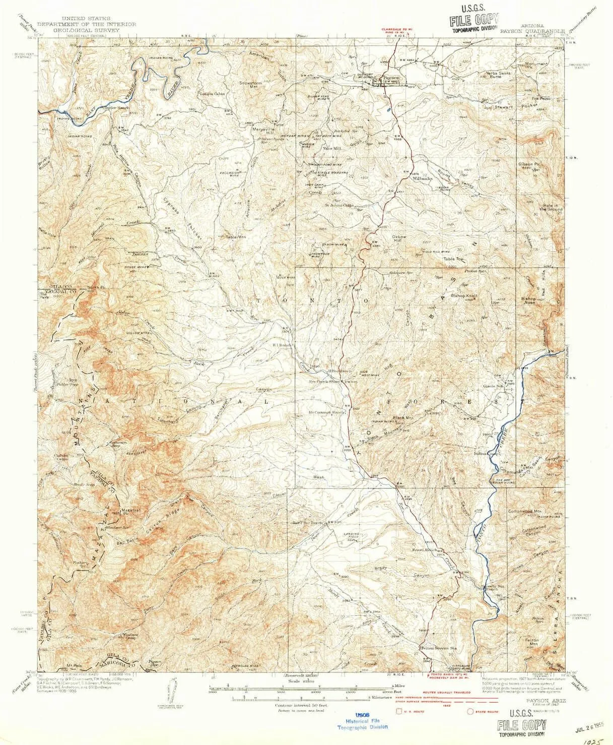
- USGS topographic map of Payson, AZ, at 1:62500 scale. Heavier material. Waterproof. Tear-resistant. Foldable. Perfect for the outdoors.
- Cities, towns, villages: Oxbow Estates,Rye,Fort McDonald,Gisela,Jakes Corner,Deer Creek Village Subdivision,Payson
- Islands: Consult topo map preview for visible islands.
- Parks and forests: Payson Rodeo Grounds,Rumsey Park
USGS topographic map of Payson, Arizona, dated 1942.
Includes geographic coordinates (latitude and longitude), lines of elevation, bodies of water, roads, and more. This topo quad is suitable for recreational, outdoor uses, office applications, or wall map framing.
Printed on-demand by YellowMaps on the print material of your choice.
Shipping rolled from Minneapolis, MN, United States.
Product Number: USGS-5548440
Map Size: 20.8 inches high x 17 inches wide
Map Scale: 1:62500
Map Type: POD USGS Topographic Map
Map Series: HTMC
Map Version: Historical
Cell ID: 60824
Scan ID: 314888
Survey Year: 1936
Datum: NAD27
Map Projection: Polyconic
Map published by United States Geological Survey
Map Language: English
Scanner Resolution: 600 dpi
Map Cell Name: Payson
Grid size: 15 X 15 Minute
Date on map: 1942
Geographical region: Arizona, United States
Northern map edge Latitude: 34.25°
Southern map edge Latitude: 34°
Western map edge Longitude: -111.5°
Eastern map edge Longitude: -111.25°
Surrounding map sheets (copy & paste the Product No. in the search bar):
North: USGS-5550486,USGS-5548482,USGS-5550488,USGS-5548488,USGS-5548484
East: USGS-5555804,USGS-5547802,USGS-5547798,USGS-5555802,USGS-5547800
South: USGS-5555346,USGS-5549442,USGS-5555344,USGS-5549436,USGS-5549434
West: USGS-5556410,USGS-5549464,USGS-5556414,USGS-5549466,USGS-5549460

")


")
 Waterproof Windproof Breathable Gore-Tex Outdoor Hunting Jacket")


