Lightweight Waterproof Backpacks&Hiking Boots
Lightweight Waterproof Backpacks&Hiking Boots Lightweight Waterproof Backpacks&Hiking Boots
Home Trail Accessories Waterproof Map Case
North Manitou Island MI topo map, 1:24000 Scale, 7.5 X 7.5 Minute, Historical, 1997, Updated 2000, 27.9 x 20.8 in

North Manitou Island MI topo map, 1:24000 Scale, 7.5 X 7.5 Minute, Historical, 1997, Updated 2000, 27.9 x 20.8 in

$ 45.00

$ 64.00

Save: $

Color:
  • Polypropylene
  • Regular Paper
  • Tyvek
Unavailable
Please select combo product attributes
The combo subtotal is $,SAVE$

Product Details

  • Printed on Polypropylene (plastic)
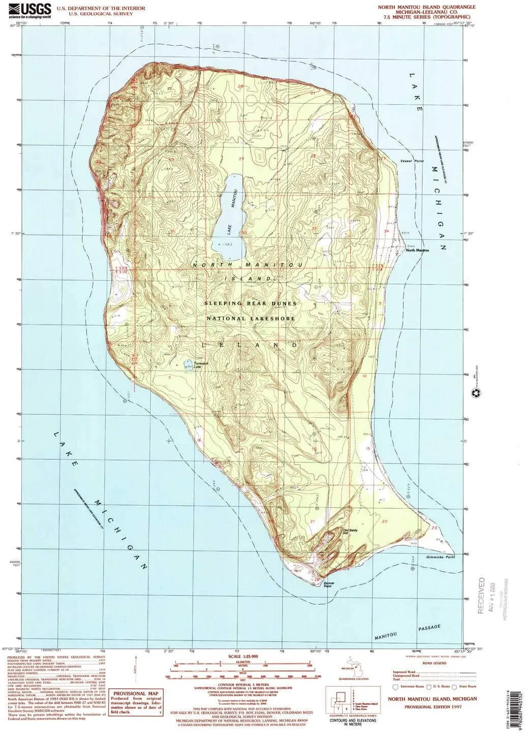
  • USGS topographic map of North Manitou Island, MI, at 1:24000 scale. Heavier material. Waterproof. Tear-resistant. Foldable. Perfect for the outdoors.
  • Cities, towns, villages: North Manitou
  • Islands: North Manitou Island
  • Parks and forests: Sleeping Bear Dunes National Lakeshore


USGS topographic map of North Manitou Island, Michigan, dated 1997, updated 2000.

Includes geographic coordinates (latitude and longitude), lines of elevation, bodies of water, roads, and more. This topo quad is suitable for recreational, outdoor uses, office applications, or wall map framing.

Printed on-demand by YellowMaps on the print material of your choice.

Shipping rolled from Minneapolis, MN, United States.

Product Number: USGS-5677080
Map Size: 27.9 inches high x 20.8 inches wide
Map Scale: 1:24000
Map Type: POD USGS Topographic Map
Map Series: HTMC
Map Version: Historical
Cell ID: 76585
Scan ID: 276814
Imprint Year: 2000
Woodland Tint: Yes
Photo Inspection Year: 1997
Datum: NAD27
Map Projection: Universal Transverse Mercator
Provisional map: Yes
Map published by United States Geological Survey
Map Language: English
Scanner Resolution: 600 dpi
Map Cell Name: North Manitou Island
Grid size: 7.5 X 7.5 Minute
Date on map: 1997
Geographical region: Michigan, United States
Northern map edge Latitude: 45.1666667°
Southern map edge Latitude: 45.0416667°
Western map edge Longitude: -86.0833333°
Eastern map edge Longitude: -85.9583333°

Surrounding map sheets (copy & paste the Product No. in the search bar):
North:
East:
South:
West:

You May Also Like

Lake Norman North NC topo map, 1:24000 Scale, 7.5 X 7.5 Minute, Historical, 1970, Updated 1992, 26.8 x 21.8 in

$ 48.00

$ 69.00

Save: $

Allin | Stylish And Comfortable Winter Boots For Women

$ 99.50

Save: $

Sea to Summit Waterproof Map Case

$ 42.99

Save: $

10L Lightweight Cycling Backpack with Helmet Net

$ 17.04

Save: $

Anleo Hard Travel Case for Geiger Counter Nuclear Radiation Detector (Black Yellow)

$ 13.00

$ 16.00

Save: $

Waterproof Wicklow East 1:25k Map

$ 23.99

Save: $

Jousen Mens Boots Leather Dress Boots for Mens Cap-Toe Fashion Boots for Men

$ 71.00

$ 130.00

Save: $

OtterBox FRE Series Waterproof Case with MagSafe (Designed by LifeProof) for iPhone - Non-Retail Packaging (Black, iPhone 14 Plus)

$ 28.00

$ 40.00

Save: $

17571.2877 Model Diver Automatic

$ 99.00

$ 623.00

Save: $

MASTOPMen's Business Quartz Watch Analog Classic Calendar Date Leather Waterproof Watch

$ 19.00

$ 24.00

Save: $

Cart
Lightweight Waterproof Backpacks&Hiking Boots
Your cart is currently empty.