- Printed on Polypropylene (plastic)
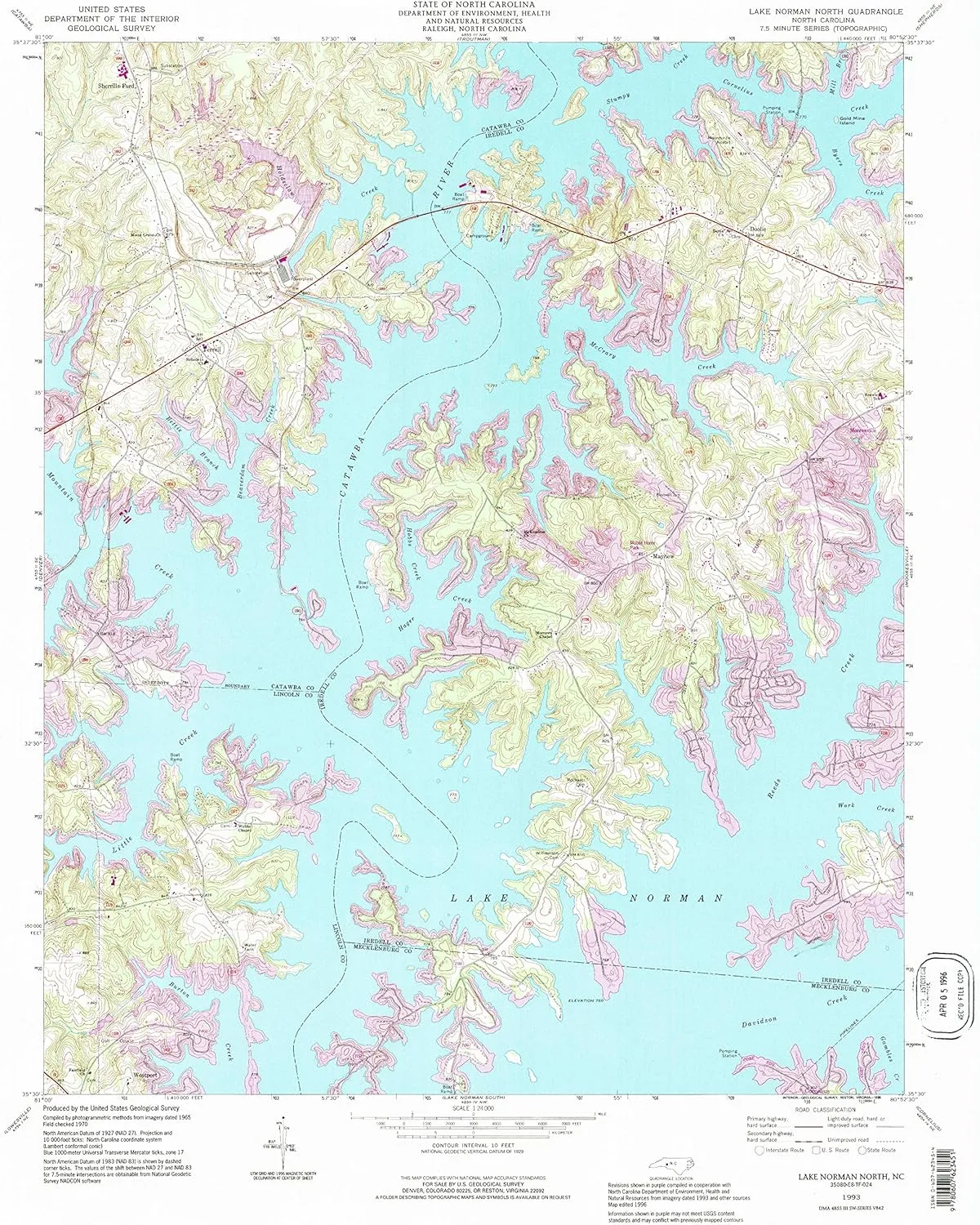
- USGS topographic map of Lake Norman North, NC, at 1:24000 scale. Heavier material. Waterproof. Tear-resistant. Foldable. Perfect for the outdoors.
- Cities, towns, villages: Sherrills Ford,Webbs,Doolie,Westport,Lake Norman,Terrell,River View (historical),Mayhew
- Islands: Gold Mine Island
- Parks and forests: Pinnacle Access Area,McCrary Access Area,Hager Creek Access Area
USGS topographic map of Lake Norman North, North Carolina, dated 1993, updated 1996.
Includes geographic coordinates (latitude and longitude), lines of elevation, bodies of water, roads, and more. This topo quad is suitable for recreational, outdoor uses, office applications, or wall map framing.
Printed on-demand by YellowMaps on the print material of your choice.
Shipping rolled from Minneapolis, MN, United States.
Product Number: USGS-5371418
Map Size: 26.7 inches high x 21.8 inches wide
Map Scale: 1:24000
Map Type: POD USGS Topographic Map
Map Series: HTMC
Map Version: Historical
Cell ID: 24587
Scan ID: 161509
Imprint Year: 1996
Woodland Tint: Yes
Aerial Photo Year: 1993
Edit Year: 1996
Field Check Year: 1970
Datum: NAD27
Map Projection: Lambert Conformal Conic
Map published by United States Geological Survey
Map Language: English
Scanner Resolution: 600 dpi
Map Cell Name: Lake Norman North
Grid size: 7.5 X 7.5 Minute
Date on map: 1993
Geographical region: North Carolina, United States
Northern map edge Latitude: 35.625°
Southern map edge Latitude: 35.5°
Western map edge Longitude: -81°
Eastern map edge Longitude: -80.875°
Surrounding map sheets (copy & paste the Product No. in the search bar):
North: USGS-5373752,USGS-5373754
East: USGS-5372060,USGS-5372064,USGS-5372058,USGS-5372062
South: USGS-5371428,USGS-5371046,USGS-5374784,USGS-5374782,USGS-5371426
West: USGS-5374940,USGS-5370036,USGS-5374820,USGS-5370040,USGS-5374822


")

](https://www.flintstart.shop/image/waterproof-phone-case-for-snorkeling-underwater-touchscreen-housing-universal-ip68-professional-waterproof-photography-amp-video-case-for-iphone-samsung-motorola-seriesup-to-69inchdrak-blue_XKEz20_300x.webp "Waterproof Phone Case for Snorkeling - Underwater Touchscreen Housing Universal IP68 Professional Waterproof Photography & Video Case for iPhone Samsung Motorola Series[up to 6.9inch](Drak Blue)")
 Waterproof Windproof Breathable Gore-Tex Outdoor Hunting Jacket")


